| Weather Data | |||
|---|---|---|---|
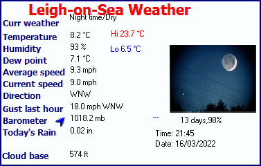
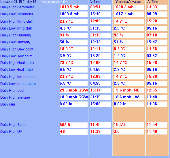
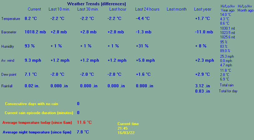
| LAST READING AT TIME: 21:45 DATE: 16 March 2022, time of next update: 22:00 | |||
| Current Weather | Night time/Dry | Current Temperature | 8.2°C (46.7°F), Apparent temp 5.7°C |
| Maximum Temperature (since midnight) | 23.7°C at: 12:09 | Minimum Temperature (since midnight) | 6.5°C at: 04:55 |
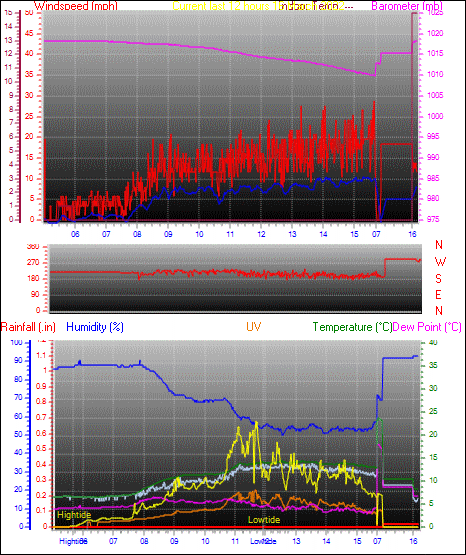
| Average windspeed (ten minute) | 8.7 mph | Wind Direction (ten minute) | WNW (285°) |
| Windchill Temperature | 6.2°C | Maximum Gust (last hour) | 18.0 mph at: 15:15 |
| Maximum Gust (since midnight) | 29.0 mph at: 15:37 | Maximum 1 minute average (since midnight) | 18.0 mph at: 21:35 |
| Rainfall (last hour) | 0.00 in. (0.0 mm) | Rainfall (since midnight) | 0.02 in. (0.5 mm) at 14:00 |
| Rainfall This month | 0.04 in. (1.0 mm) | Rainfall To date this year | 4.35 in. (110.5 mm) |
| Maximum rain per minute (last hour) | 0.00 in/min | Maximum rain per hour (last 6 hours) | 0.02 in/hour |
| Yesterdays rainfall | 0.02 in | DewPoint | 7.1°C (Wet Bulb :7.7°C ) |
| Humidity | 93 %, Humidex 8.2°C | Barometer corrected to msl | 1018.2 mb |
| Pressure change | +2.8 mb (last hour) | Trend (last hour) | RISING SLOWLY |
| Pressure change (last 12 hours) | -0.0 mb | Pressure change (last 6 hours) | +2.5 mb |
| Maximum Pond Temp temperature (since midnight) | 23.3°C | Minimum Pond Temp temperature (since midnight) | 7.8°C |
| Current Pond Temp temperature 100°C | |||
| Current solar | 0 W/m� | Current UV | 0.0 |
| Maximum solar (since midnight) | 868 W/m� | Maximum UV (since midnight) | 4.0 |
| Current 02:01 hours of sunshine today, current sky: Night time/Dry | |||
| Sunshine hours for the year: | 399:59 hrs | Sunshine hours for the month: | 11:08 hrs |
| Current evapotranspiration 0.09 inches per day. Yesterday's reading 0.08 | |||
Use the RELOAD facility on your browser to retrieve the latest data.